
Thomasville Street Directory Walkthrough
Start with Davidson County WebGIS, not a broad name list. Its physical-address and street-name tools place a Thomasville address in the current map context and can expose the parcel ID, PIN, tax parcel address, owner fields, ZIP layer, municipality layer, and neighborhood code. That first record is geographic evidence. It does not establish that every name tied to the parcel currently lives there. Keep the visible map extent small enough to show the relevant stretch of road, then save the parcel and PIN before moving to the tax and deed systems.
- Search the physical address or street name in Davidson County WebGIS. Use Identify or Select on the pertinent parcel and record the PIN, parcel number, road label, municipality, ZIP layer, and date of the search.
- Enter the PIN or properly abbreviated property address in the Tax Real Estate Search. Compare the situs address, assessment mailing address, tax year, owner field, and zoning without treating any one field as proof of occupancy.
- Use the parcel's legal description, book/page, or current record party in the Davidson Deeds Name Search. Search both sides of a transaction when tracing a transfer, and look for document type Release when a satisfaction is relevant.
- For a current public election record, use the North Carolina voter lookup, then contact the Davidson County Board of Elections for correction, precinct, or written-list questions. A voter entry is limited to the public fields and can be masked for safety.
- For an older address association, take the current and earlier street labels to the Davidson County Genealogy and History Room or a digitized Thomasville directory. Match the printed year and address before drawing a historical conclusion.
That order prevents a common error: a mailing address, a sales result, and a voter entry are different kinds of evidence. The Thomasville street directory approach is strongest when the reader preserves each source's role instead of collapsing them into one claim.
Thomasville Streets in WebGIS
WebGIS is the county's best tool for browsing a named street because the tax forms do not expose a dedicated street-browse mode. The map allows owner-name, parcel, PIN, tax-address, physical-address, street, neighborhood, legal-land, value, sale, and deed-date filters. It can limit results to the current map extent and export the visible result set as CSV. The county legend also identifies address points, roads, ZIP layers, polling places, schools, fire and emergency-service districts, historic districts, tax neighborhoods, and municipality layers. Those layers provide context, not proof of a resident's identity.
For a road that crosses the Thomasville line, record the municipal layer separately from the postal city line. The GIS disclaimer says its information comes from public and private sources, accuracy is not guaranteed, and the map is not a survey substitute. Use an official office record when a boundary or ownership question needs confirmation.
| WebGIS field or tool | Input type | Street research use |
|---|---|---|
| Physical Street Address or Street Name | Text | Find a location or browse a road segment. |
| Parcel ID, Parcel Number, or PIN | Text | Carry the parcel key into Tax and Deeds. |
| Owner Name 1 or 2 | Text | Compare current record parties after a parcel is known. |
| Neighborhood Community and Neighborhood Code | Text or selector | Keep map context with the street result. |
| Sale Year, Deed Date, and Sale Price | Ranges | Find a dated transaction for later deed checking. |
| Map Extent, Identify, Select, and CSV | Map tools | Define and preserve the exact area examined. |
Note: A map export is a working list for a defined extent, not an official certification of ownership or residence.
Thomasville Street Tax Search Fields
The Davidson tax system supplies the parcel record behind a street result. Real Estate Search accepts owner last and first name, account number, a split parcel number, tax year, PIN, property address, and a zoning selector. Its street search expects abbreviations such as RD or ST. The form exposes tax years from 2016 through 2026, including an All Years choice. The site advises using one main identifier rather than several competing inputs. A tax record can show assessed ownership and the assessor's address fields, but it cannot turn a property association into a full household list.
The Davidson County Sales Search illustrates a different, property-focused workflow. It accepts a required date range plus map extent, building, bedroom, bathroom, year-built, sale-price, and neighborhood controls.
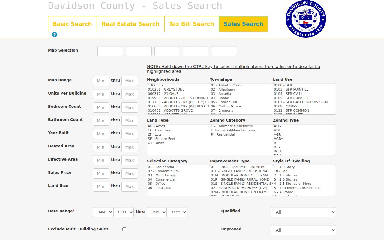
The sales screen is useful for locating a transaction to verify elsewhere. It is not a person search, and a sale match does not establish who was at the address on any particular date.
Tax Bill Search uses the same name, account, parcel, tax-year, and address paths, with bill number, unpaid-only, and sort options added. Its interface distinguishes record retrieval from a conclusion about title or a person's current location.
The Davidson County Tax Bill Search shows those address, account, parcel, and tax-year controls in one place.
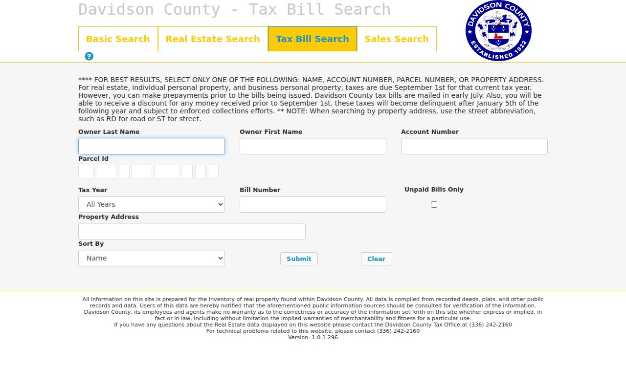
An unpaid-bill filter is only a tax-status tool. It is not evidence of a completed transfer, a court outcome, or who is presently at the property.
Thomasville Street Directory Records
Address-keyed records answer different questions. The county tax roll ties an address to an assessment account. WebGIS shows the mapped parcel and layers. Deeds identify parties to a recorded transaction, while voter data is an election record with statutory exclusions and safety protections. Historic street directories and maps add dated context. Keeping the source type beside every result is more reliable than treating the same street line as a single record.
| Street-keyed source | What it can show | Thomasville access path | Important boundary |
|---|---|---|---|
| Tax parcel and assessment | Assessed owner, parcel, mailing and situs address, values, zoning, tax year | Tax search, download request, or Assessor office | Assessment fields do not prove occupancy. |
| WebGIS parcel map | Parcel, PIN, road, ZIP, municipality, district, neighborhood, map extent | Interactive WebGIS and GIS legend | Not a survey or identity record. |
| Deed or release | Recorded parties, legal description, transfer date, instrument trail | Online index from 1984 forward; Register counter for earlier material | Does not list every person using the address. |
| Voter registration file | Public voter address, status, precinct, and other allowed election fields | State lookup, county board, or defined written request | Protected addresses and excluded fields remain protected. |
| Permit, code, or historic file | Application, inspection, work, or approval associated with property | Thomasville Planning and Inspections request route | A named applicant may have a role other than residence. |
| Criss-cross directory or map | Dated address-to-household or business association, historic street label | Genealogy Room, DigitalNC, museum, and map collections | It is a historical snapshot, not a current roll. |
Davidson Tax Database Downloads supplies another channel when a narrow existing extract is more useful than a web form. The request form permits Excel, PDF, text, CSV, or printed output, and the office determines estimated cost, processing time, and available materials after review. State Archives holdings and library sources are the fallback for historic material that does not appear in a modern screen.
Thomasville Street Record Terms
Street research becomes clearer when property terms stay distinct. A legal description may survive a changed road name even when the printed street number does not. If more than one parcel shares an apparent number, use the parcel identifier, legal description, ZIP layer, and municipality layer to separate them before a deed or historic directory search.
- Parcel
- A defined tract in the tax and map system, usually identified by a parcel number or PIN.
- Situs address
- The physical location assigned to the property. It is different from the mailing address used for tax correspondence.
- Plat
- A recorded map of a subdivision, lot, or boundary. A color-coded plat may require an office copy if the online image is unavailable.
- Criss-cross directory
- A reverse directory arrangement that starts with an address or street and associates it with a dated printed entry.
Note: Save the exact field label, query date, and street spelling so another searcher can tell physical, postal, and assessment addresses apart.
Thomasville Main Street Address Changes
The railroad through central Thomasville creates a high-value address trap. The State Historic Preservation Office material reports that North and South Main on either side of the rail line were eventually renamed West and East Main. A literal search for only one modern label can miss a directory, map, or deed description that used the earlier wording. Historic street work should therefore capture the old label, current label, date, source page or map sheet, and any parcel key that connects them.
Davidson County's uniform road-name and address program was targeted to begin on April 27, 1992. Early directory and deed labels may reflect route-based, abbreviated, older, or renumbered addressing. For a missing match, try direction changes, abbreviated and spelled-out suffixes, Rural Delivery notation, nearby cross streets, and the earlier number. The county has not supplied a complete official annexation or address-realignment table for every Thomasville street, so each proposed match needs a source-based crosswalk.
Thomasville Street Directory Marks
Historical street entries require their own reading rules. The 1933 Thomasville directory uses h for householder, r for roomer or resides, and RD for Rural Delivery. Those labels should remain attached to the year and source, rather than being rewritten as a current status. The 1935 directory described a house-to-house canvass and the use of additional materials, a useful clue about how that particular snapshot was assembled.
Use the old street section as a dated handoff, not a replacement for current parcel research. Compare its printed address with the 1890 Thomasville inset, 1938 map or Sanborn material when a current address cannot be found directly. The DigitalNC record for the 1933-34 Thomasville directory is a useful route to a digitized historical volume, while the local library and museum can help identify companion maps and vertical files.
Note: When current and historic labels differ, preserve both spellings and the source that connects them.
Thomasville Street Evidence Compared
Three address systems often appear in the same search but answer different questions. Postal tools standardize a mailing line. GIS places a parcel or street segment in a current spatial layer. Tax and deed records supply property evidence that must still be checked against their date and field labels. The comparison matters most near city limits, on renamed roads, and when a tax mailing address is outside the situs location.
| System | Best question | Do not infer |
|---|---|---|
| USPS address tools | How should a full mailing address be standardized? | A postal line proves a person is at the address. |
| Davidson WebGIS | Where is the parcel or street segment, and which public layers meet it? | The map is a survey or a household roster. |
| Tax and Deeds | Which assessed or recorded property fields belong to the parcel? | Every listed party currently occupies the property. |
Once a ZIP or map result has narrowed the geography, the Thomasville ZIP code lookup helps distinguish postal coverage from the city boundary before a street result is compared.
Thomasville Street Directory Limits
No public Thomasville source reliably lists every household member, guest, mail recipient, or other occupant at a property. A deed identifies recorded parties; a tax card identifies assessment fields; a permit may name an applicant; a voter record identifies a registered voter within the public file; and a historic directory prints a dated entry. None is interchangeable with the others. DMV addresses are restricted, and utility or delivery-customer information is not a public substitute.
Use a defined question and share only what is necessary to support it. Under North Carolina's voter rules, qualifying protective orders and Address Confidentiality Program participation can keep an address confidential. If a result is protected or uncertain, do not use nearby public fields to recreate it.
Lawful use. Thomasville street and parcel records are for legitimate personal research and civic reference. Do not use address information to stalk, harass, intimidate, or harm another person.
When a needed record is unavailable online, use the custodian route: the Tax Assessor for assessment data and a Tax Database Downloads request, the Register counter for recorded real estate, the Board of Elections for voter-file questions, Thomasville Planning and Inspections for address-keyed municipal files, the library or museum for local history, and the State Archives for transferred county material. The Register provides public computers and self-service kiosks, while material before the 1984 online deed boundary may need its office, library, or archival route. That is more accurate than guessing from an incomplete street result.